Op 8 juni 2010 verlaten we de bunkhouse van de Bridge of Orchy Hotel in 8:35 AM. We passeerden de onderdoorgang nabij het station en even later de zendmast. Er waren laaghangende wolken, maar we zagen de pas. De toppen van beide Munro’s werden omhuld door wolken. Het regende niet. Omdat het de dag ervoor wel had geregend was het pad plaatselijk zeer nat en moerassig.
In 1 h 25 min bereikten we de pas op 744 meter. De wind was sterk, dus we deden onze windstopper aan. Omdat het weer ons onstabiel leek, ging we eerst naar Ben Dorain, zodat op de weg terug naar de pas alsnog konden kiezen om ook naar de andere top te gaan of terug te gaan naar het hotel. Omhoog lopend bereikten we in no-time het niveau van de lage wolken. Het zicht was beperkt tot ongeveer 50 meter en werd minder tijdens toen we het stijgende pad bleven volgen. Onze GPS wees ons de weg. Ik weet zeker dat, zonder een GPS we al eerder zouden zijn omgekeerd.
Na enige tijd dook een grote steenman op uit de mist, Carn Sasunnaich. De hoogtemeter vertelde ons datdit nog niet de top was. Verder lopend bereiken we uiteindelijk na 1 uur lopen vanaf de pas de top van Ben Dorain. Het zicht was slechts 20-30 m bij 100% luchtvochtigheid en in combinatie met een stevige wind, geen pretje om daar lang te blijven. Na het maken van foto's (als bewijs dat we op de top waren!) begonnen we aan de afdaling. Wij zijn als enigen op de helling, samen met enkele schapen.
Na ongeveer 50 minuten zijn we weer terug bij de pas. Het zicht was hier beter, we zaten ten minste onder de wolken zodat we het treinstation en het hotel konden zien.
Twee mensen kwamen het pad richting pas omhoog . We maakten een kort praatje. Ze wilden ook de Munro’s doen. Na een korte pauze en controle van het weer, gingen we richting 2e top de Ben an Dothaidh. Na het steile gedeelte in het begin volgden we het stijgende pad, maar onze GPS gaf aan hoe te lopen omdat het zicht wederom slechts 30 meter bedroeg. Maar de GPS stuurde ons de juist de moerassige helling op. Eerst bereikten we de centrale top, snel een foto gemaakt en toen ginge het snel door naar de tweede meer westelijk gelegen top. Nog steeds weinig zicht. De wind was nog steeds vrij matig, zodat we zo snel mogelijk terug naar de pas liepen, weer door de moerassige helling. Geen pad te vinden, alleen maar vertrouwen op onze GPS.
In 40 minuten vanaf de centrale top bereikten we de pas. Net onder de pas, uit de wind, namen we een korte pauze om te eten en te drinken. Onder deze weersomstandigheden, was die tweede Munro niet echt lonend. Tijdens de afdaling begon het te motregenen. Na enige tijd deden we toch maar onze regenjassen aan.
Maar we waren trots dat dit toch weer mooi gedaan hadden, ook omdat we al 3 Munro’s hadden beklommen. Het virus van Munro-bagging was voelbaar !
Terug in de bunkhouse namen we een warme douche en in het hotel trakteerden we ons zelf op een koude pint.
Enige tijd later kwam de andere mensen ook binnen. Ze waren inderdaad beiden tot de top van de Ben Dorain gegaan en terwijl zij bij de steenman op de pas wachtte, deed hij de Ben an Dothaidh. Heel moedig onder deze weersomstandigheden.
Totale tijd 6 uur inclusief rust.
After climbing Ben Lomond on June 4th we continued walking the West Highland Way. But our next goal were the Munro’s nearby Bridge of Orchy, Ben Dorain and Ben an Dothaidh.
Walking in the direction of Bridge of Orchy we noticed the huge conical-shaped Ben Dorain.
On June 8th 2010 we left the bunkhouse of the Bridge of Orchy Hotel at 8:35 AM. Behind the underpass at the train station we passed the transmitting tower.
There were low clouds but we could see the bealach. The summits of both Munro’s was in the clouds.
But it wasn’t raining.
Because it rained the day before the path became very boggy.
In 1h 25 min we reached the bealach at 744 m.
The wind was strong so we put on our windproof jackets.
Because the weather looked unstable to us, we first went up to Ben Dorain , so that on the way back to the bealach we could choose to go for the other summit or to go back to the Hotel.
Going up, in no time we reached the level of the low clouds.
The visibility was poor, about 50 m and decreasing while climbing higher and higher. Our GPS pointed out were the go. I’m sure, without a GPS we would have returned already.
After some time a big cairn came out of the fog, Carn Sasunnaich. Checking the altitude it couldn’t be the summit. Further on, in 1hour from the bealach, we reached the summit of Ben Dorain. Visibility: 20-30 m 100 % humidity in combination with brisk wind, so it wasn’t pleasant to stay there for long. After making pictures (to prove we were on the summit !) we started to descend. We were the only people on the slope, together with some sheep.
At about 50 minutes we were back at the bealach. The visibility was again better, we were below the clouds so we could see the train station and the Hotel. A couple was climbing the corrie and came closer. We had a short chat. They also wanted to tackle the Munro’s.
We took a short break to eat and drink and checking the weather, we headed for the summit of Ben an Dothaidh. Again our GPS told us were to go as the visibility was again decreasing to 30 m.
After the steep part in the beginning we followed the ascending path, but looking at the GPS we had to walk due north right trough boggy slopes. I still love my gaiters.
We first reached the central summit, made a picture and then went on to the western summit. Still no visibility. The wind was still quite moderate so we walked as quickly as possible back to the bealach, again through boggy slopes. No path to find, just trusting our GPS. We got to the bealach again in 40 minutes from the central summit. Just below the bealach, out of the wind we took a short break to eat and drink.
Under this weather conditions, this second Munro was not rewarding at all.
While descending the corrie it started drizzling. After some time we put on our raincoats.
We were proud we did this, but also because we collected already 3 Munro’s. We felt the bug to do more Munro’s !
Back in the bunkhouse we got a warm douche and then we treated ourselves on a cold pint.
Some time later the other people came in. They had done Ben Dorain and while she was waiting at the cairn at the bealach, he did Ben an Dothaidh. Quite brave in this conditions.
Total time: 6 hours including breaks.

Photo: The bealach at the left our first goal. Low clouds cover the summit of Ben Dorain

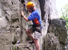
Photo: Checking map and altitude.

Photo: Just below the bealach

Photo: At the bealach, 744 m

Photo: Poor visibility

Photo: Summit Ben Dorain

Photo: Summit Ben an Dothaidh


Geen opmerkingen:
Een reactie posten